ArcGIS Infrastructure Migration for the Indiana Geographic Information Office
About Indiana Geographic Information Office (GIO)
The GIS Office contributes to the quality of Indiana as a place to live and work by cultivating statewide geographic information resources (relationships, data and technology) so that individuals and organizations across the state have suitable access to accurate and relevant geographic information and technology.
The Challenge
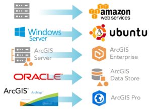
For well over a decade, Indiana’s Geographic Information Office has managed a library of over 300 geospatial datasets for access and use by state government employees and the public. The infrastructure that supported the library consisted of two on-site ESRI ArcGIS servers that were load balanced with Oracle as the database backend. Datasets were accessed via hundreds of services. The servers had to be provisioned with high enough virtual memory to be able to host the large number of services. This combined with the high volume of traffic was pushing the limits of the existing hardware. In addition, connectivity was cumbersome for users who were required to access the library via Virtual Private Network (VPN) technology.
The Solution
The state wanted an alternate solution that would be scalable, cost-effective, and allow users to connect securely to the data and services from any location without using VPN. Collectively, these challenges strongly favored a solution that would migrate the infrastructure to the cloud and resolve issues related to:

geoConvergence designed a cloud infrastructure to overcome these challenges and meet future needs such as: collaborations with various state agencies, the deployment of an open data portal using ArcGIS Hub and the eventual realization of a “system of systems” promoted by Esri’s visionary leader, Jack Dangermond.
Working closely with the GIO, the architecture was designed not only to be scalable but also highly available and resilient. geoConvergence used CloudFormation templates to automate the deployment of the various ArcGIS Enterprise infrastructure components which were specifically architected for the AWS Cloud. ArcGIS Enterprise was then connected to the Azure AD for security and single sign-on access.
A close examination of user workflows identified the opportunity to streamline operations by removing Oracle and the enterprise geodatatabase from the architecture and employing an ArcGIS Data Store and hosted feature layers instead. Additional performance was gained by implementing distributed and partner collaborations to avoid duplication of data that were already published by collaborating agencies.
Ultimately, geoConvergence was able to partner with the GIO’s office to create a versatile and efficient ArcGIS Enterprise platorm that is secure and scalable.
“The State of Indiana needed to modernize our system of data hosting and delivery to take advantage of the latest technologies and capabilities that align with the longterm strategic vision. The first step was migrating our GIS Infrastructure to the AWS Cloud, laying the foundation to establish a secure and scalable platform for the future.”
Megan Compton, State of Indiana GIO
gio@iot.in.gov

