
From Soups to Weapons
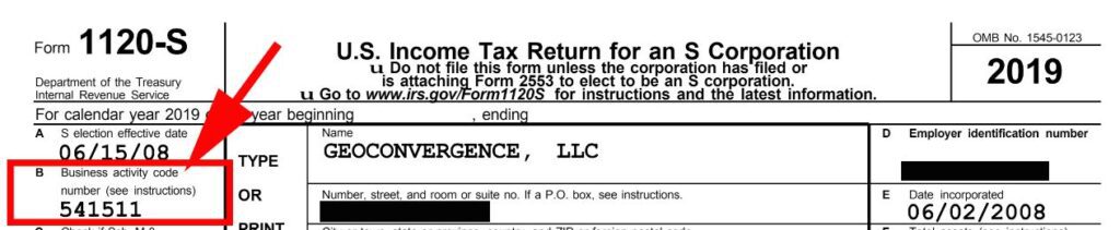
From Soups and Bouillons to Coffee, Tea, and Cocoa to Weapons, the United States Federal Government is the world’s largest purchaser of goods and services. If your company desires to offer products and services to the government, the first step is to get registered with SAM (System for Award Management). https://beta.sam.gov/ During your SAM update or registration, there is an important marketing section named “Assertions.” In this section, you are educating the government on your broad offerings by listing NAICS codes. NAICS is an abbreviation for North American Industry Classification System. You may list multiple NAICS but one of them must be identified as your “Primary NAICS Code.” Please note that your primary NAICS Code is also reported on your Federal Tax returns as your “Business activity code number.” (see image below) NAICS codes broadly define your offerings but do not provide enough granular information for the government to gain a full understanding of your business without reviewing your capability statement or website. This is where PSC Codes come into play. PSC stands for Product Service Code. For example, geoConvergence’s primary NAICS Code is 541511 (Custom Computer Programming Services). This would be similar to telling a crime investigator that the suspect was 6’ tall. PSC codes allow for more detailed information about the suspect such as having brown hair, hazel eyes, fair skin and a tattoo of a ninja on the right arm. Using geoConvergence as an example, we provide PSC codes to support 541511 such as DA01 – IT AND TELECOM – BUSINESS APPLICATION/APPLICATION DEVELOPMENT SUPPORT SERVICES (LABOR). DA01 is further defined as “Support services for activities involved with application development and support to include analysis, design, development, coding, testing, and release packaging, as well as the support of off-the-shelf Business Applications. User Research, Human Center Design, Development/Security/Operations (DevSecOps), Customer Experience (UX). Application development for new software projects and support for existing applications.” As you can see, this PSC code gives more granular information to support our NAICS Code 541511 (Custom Computer Programming Services). As we close out 2020, now is a perfect time to update your SAM profile with as many PSC codes that describe your offerings. Here are a few additional resources regarding PSC codes. DoD memo on how it uses PSC Codes to support strategic sourcing: https://www.acq.osd.mil/dpap/policy/policyvault/USA004219-12-DPAP.pdf PSC Manual: https://www.acquisition.gov/Psc-manual * PSC Selection Tool: https://psctool.us/ * The PSC Selection Tool allows users to search for the right PSC by keyword search, code search, or using the Federal Government’s category management (CM) spend categories. These categories, as established by the Office of Management and Budget (OMB) and the cross-agency Category Management Leadership Council (CMLC), group together like products or services to enable the government to buy smarter and more like a single enterprise, delivering more savings, value, and efficiency for Federal Agencies. The tool also allows searches by DoD’s legacy sixteen portfolio groups that were established under the Better Buying Power initiative.
Wrapped In Love 2020-2021

Every year, teams and individual fabric artists lovingly create tree sweaters for dozens of downtown Bloomington, Indiana trees. Each beautiful tree sweater is sponsored by a business, person, or organization committed to helping us provide meaningful alternatives to living with violence. geoConvergence donates resources and time to Wrapped In Love by mapping the locations of sponsored trees, population information and attaching photos to these tree points. The Wrapped in Love project is an annual Bloomington Middle Way House (MWH) tradition. The MWH’s vision is to end domestic and sexual violence in the lives of all people. MWH works to support all survivors of domestic violence, sexual assault, and human trafficking; and to educate the community through outreach and prevention programs. Learn More About The MWH View 2020-2021 Interactive Map
ArcGIS Indoors

geoConvergence has successfully deployed ArcGIS Indoors for a facility and asset management project for the Global Deterrence and Defense Department of the Naval Surface Warfare Center at Crane. This project involved an enterprise implementation of Esri’s new ArcGIS Indoors platform and has improved the staff’s ability to visualize and understand their workplace environment and optimize the use of available space.
Engineers Without Borders (Indianapolis Chapter)
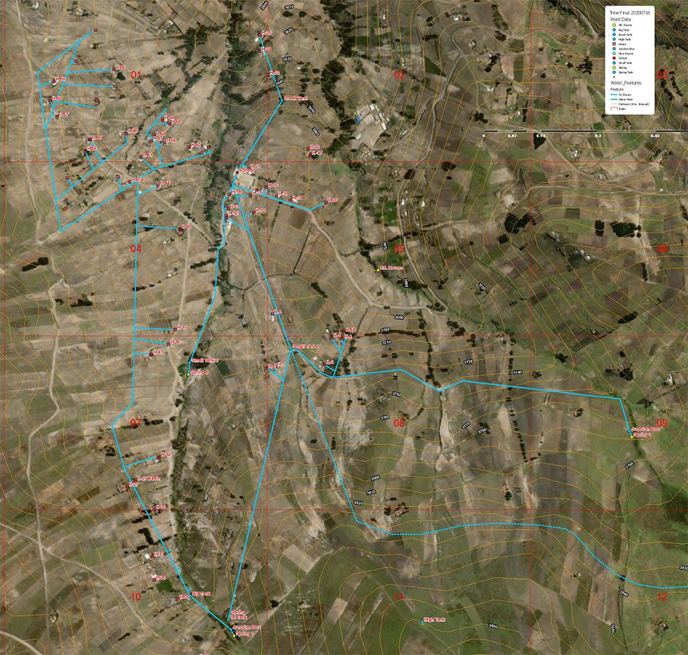
Clean Water Project in Comuna Guangaje, Ecuador Study Area August 3, 2020: geoConvergence develops a geospatial product for the Engineers Without Borders USA (EWB-USA) Indianapolis chapter’s clean water project in Comuna Guangaje, Ecuador. EWB-USA is a non-profit that builds a better world through engineering projects that empower communities to meet their basic human needs and equip leaders to solve the world’s most pressing challenges. When the Indianapolis chapter initially visited the community 3 years ago, they encountered a water storage and delivery system that had reportedly been installed by another NGO, possibly SwissAid, years earlier. The community had no drawings or documentation of its system, and management of it was difficult to explain. While the addressable problem of water input from springs to storage tanks was easy enough to see, the Indianapolis chapter struggled to understand how the system itself was architected for function. That didn’t stop them from improving the springs-to-tank channels earlier this year, but they had continually sought to help both the chapter and the community to better understand the system. Over the past year, the chapter worked with a local Indiana-based geospatial company, geoConvergence, to develop and refine a map of the system. geoConvergence was able to access both topo data and current satellite imagery to produce a useful map of the area and its above-ground infrastructure. This enabled the chapter to work with the local water committee to develop a good map of the water delivery infrastructure. This map has become an invaluable tool for the community leadership in managing system operation as well as for the chapter helping them understand, how to manage it better.
Broadband (Indiana Public WiFi Locations)

geoConvergence has been contracted by the State of Indiana’s Geographic Information Office to develop a map of publicly available locations that provide WiFi internet access. These locations can be used as a public resource for remote learning or working remotely. The sites are accessible at all hours from a parked vehicle on the road or parking lot. As a COVID-19 safety precaution, visitors are encouraged to follow guidance on the Back On Track website. VIEW PROKECT