
AFRS Provides Enhanced Recruitment Insights with Cloud-Based Geo Mapping Application
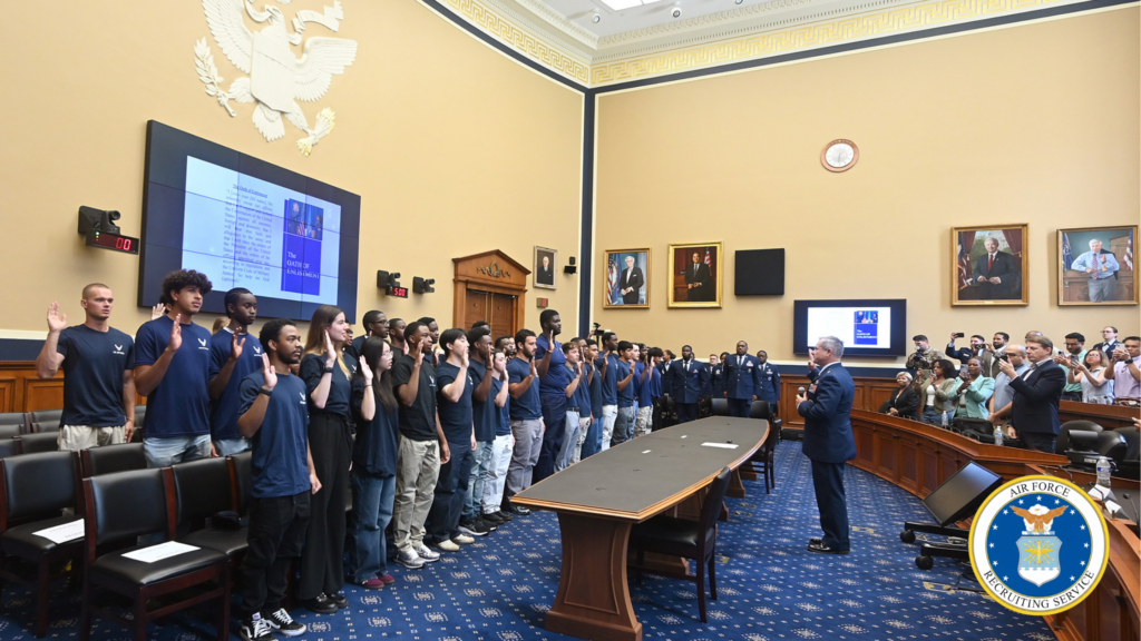
Brig. Gen. Craig McPike, Air Force Recruiting Service deputy commander, hosts a swearing-in ceremony for members of the Delayed Entry Program at the Rayburn Office Building in Washington, D.C., Aug. 15, 2025. (U.S. Air Force photo by Andy Morataya) AFRS Provides Enhanced Recruitment Insights with Cloud-Based Geo Mapping Application Client: U.S. Air Force – Air Force Recruiting Service In 2022, the U.S. Air Force Recruiting Service (AFRS) faced increasing challenges displaying and analyzing geographic-related recruiting data to assist recruiting strategies and operations. Their legacy system, reliant on an outdated on-premise infrastructure, hindered staff and recruiters’ ability to access and use geospatial information for effective recruitment planning and analysis. To address these limitations, AFRS initiated a project to replace its legacy system by migrating to a modern, scalable, cloud-based solution. The modernization aimed to provide AFRS with enhanced data visualization and analysis tools identifying high-potential recruitment areas and other insightful market information. geoConvergence was selected to bring this vision to life. geoConvergence created and migrated AFRS’s new system to Amazon Web Services (AWS) and developed a novel geo mapping application, integrating demographic, economic, and location-based data sets to create a highly available database. By November 2023, the application provided AFRS staff and recruiters access to over 70 layers of geospatial information, including historical recruiting information, population demographics, education levels, and economic indicators. The enhanced database allowed recruiters to identify high-potential recruitment areas and optimize resource allocation based on specific regional characteristics. The project marked the beginning of a new era in delivering data-driven recruiting information for AFRS. THE CHALLENGE AFRS recruits throughout the U.S. and abroad, serving over 2500 recruiters in both the Air Force and Space Force. Their legacy system faced several limitations: Data accessibility: Recruiters could only access the system from a specific AFRS intranet location, limiting field operations. Performance issues: The system experienced frequent slowdowns, with response times for complex queries often too long to be practical for recruiters’ needs. Limited data integration: The system struggled to incorporate external demographic data. Security constraints: Outdated security protocols restricted implementation of modern authentication methods, impeding secure remote access. Scalability challenges: The infrastructure could not efficiently handle peak loads during high-volume recruitment periods. These limitations resulted in: Recruiters spending significant time on manual data compilation and analysis, reducing their efficiency. Underutilization of available demographic data due to the system’s limited capabilities. Limited geospatial capabilities restricted recruiters’ ability to visualize and analyze regional recruitment trends. “geoConvergence’s solution to AFRS’s mapping requirements increased our ability to visualize and analyze the recruiting landscape for both strategic and tactical decision-making purposes.” – Eric Carlson, Market Research Analyst, Air Force Recruiting Service (AFRS) THE SOLUTION geoConvergence developed an all-embracing Geo Mapping Application for AFRS, utilizing AWS technologies and ArcGIS 10.9 at the time (the current version is 11.1). The solution was comprised of: Cloud Migration: Transferred existing infrastructure to AWS cloud Utilized services including S3, CloudFront, and Amplify Implemented Infrastructure as Code (IaC) with CloudFormation for environment management Mapping Application: Developed using ArcGIS JavaScript SDK and Experience Builder Integrated over 70 layers of geospatial information Implemented data visualization and analysis tools User Management System: Built on AWS Cognito Implemented two-factor authentication Designed enhanced user access approval workflows Data Enrichment: Integrated demographic and tapestry data from Esri Business Analyst Automated data processing and updates using custom scripts Enterprise GIS Deployment: Implemented ArcGIS Enterprise in AWS Configured for high availability and performance Maintained 95% SLA using native and custom cloud tooling Security Enhancements: Implemented secure access protocols Utilized AWS security best practices Ensured compliance with Air Force cybersecurity standards The solution modernized AFRS’s recruitment process by providing a secure, cloud-based geospatial analysis platform. Recruiters could now leverage dozens of layers of enriched demographic data to identify and engage with potential candidates more effectively. “Moving our mapping application to an AWS, cloud-based environment alleviated numerous IT access roadblocks. Our recruiters can now reliably access the mapping application anytime, anywhere.” – Eric Carlson, Market Research Analyst, Air Force Recruiting Service (AFRS) KEY FEATURES Over 70 different layers of information for data visualization and analysis Enhanced secure access using AWS Cognito with two-factor authentication Custom experience builder application for Air Force and Space Force recruiters Automated data processing and updates using scripts Serverless, scalable architecture optimizing content delivery performance worldwide IMPLEMENTATION geoConvergence created a completely new mapping tool for AFRS, far surpassing its legacy system by focusing on cloud migration, advancing mapping capabilities, and enhancing data use and access. The implementation centered on: Cloud Migration: Transferred existing infrastructure to AWS Utilized S3 for application deployment Implemented CloudFront for content distribution Leveraged Amplify for application development and deployment Employed blue/green deployment methodology for seamless updates Application Development: Created JavaScript Mapping Application using ArcGIS JavaScript SDK and Experience Builder Developed User Management Application with AWS Cognito Implemented AWS services including RDS, Elastic Cache, and SQS Data Enrichment: Integrated demographic and tapestry data from Esri Business Analyst Developed automated scripts for data processing and updates Security Enhancement: Implemented two-factor authentication with AWS Cognito Designed enhanced user access approval workflows Ensured compliance with Air Force cybersecurity standards Testing and Optimization: Conducted E2E testing using Protractor Performed unit testing with Jasmine/Jest/Karma Executed integration testing, user acceptance testing, load testing, and security testing Deployment and Maintenance: Utilized AWS CodeBuild for code compilation Implemented AWS CodePipeline for automated deployment workflows Established 24/7 Level 1 and Level 2 technical support geoConvergence leveraged its geospatial development and cloud architecture expertise to produce a solution that implemented custom AWS Cognito workflows and multiple MFA methods, including SMS authentication. The team worked hand-in-hand with AFRS personnel throughout the project, incorporating feedback and making iterative improvements to ensure the solution met evolving needs and requirements. “AFRS’s collaboration with geoConvergence has created a mapping application meeting the specific needs of our recruiting force. We’ve continued to enhance the tool based on feedback from our users and suggestions from geoConvergence.” – Eric Carlson, Market Research Analyst, Air Force Recruiting Service (AFRS) RESULTS AFRS’s on-line mapping application transformed how recruiters visualize and analyze the recruiting
Indiana Geospatial Intelligence Firm Wins Navy Subcontract

Indiana Geospatial Intelligence Firm Wins Navy Subcontract 5 year-contract for Sensors & SONAR Systems Rapid Prototype Development (Odon, IN – November 9, 2021) geoConvergence, an SBA 8(a) Certified Small Business geospatial intelligence firm, will serve as a subcontractor to Booz Allen Hamilton on a five year, indefinite delivery indefinite quantity (IDIQ) contract with a value of up to $48,993,390. The Department of the Navy contract will be performed at Naval Sea Systems Command, NUWC Newport Division and will run through 2026. “We are proud to be partnering with Booz Allen Hamilton on this important contract,” said Prem Radhakrishnan, co-founder & CEO of geoConvergence. “Opportunities like this allow private industry to help push our national security to the next level with state-of-the-art technology.” The geoConvergence team will be involved in software development and prototyping for SONAR systems—developing new capabilities for maritime operations. “geoConvergence leverages years of past performance serving the Department of Defense,” said Radhakrishnan. “Our capabilities include ArcGIS Indoors, as well as a suite of geospatial intelligence-related services all designed to create smarter, better-optimized systems, facilities and operations.” About geoConvergencegeoConvergence is a SBA 8(a) certified, minority-owned small business. The firm specializes in the design and implementation of world-class Geospatial Intelligence, Geographic Information Systems (GIS), and Space Management solutions by leveraging technical skills in Software Development (SecDevOps), Cloud Engineering, and Data Analytics required to create secure, effective, efficient, and resilient solutions in today’s highly connected network environment. For more information, visit https://geoConvergence.com
Indiana Strategic Defense Accelerator (INSDA)

Indiana Strategic Defense Accelerator (INSDA) (Odon, IN – August 31, 2021)This video was made possible by the Indiana Strategic Defense Accelerator (INSDA), a collaboration between the Gayle and Bill Cook Center for Entrepreneurship at Ivy Tech Community College Bloomington and Naval Surface Warfare Center Crane Division (NSWC Crane). By supporting non-traditional defense contractors, INSDA endeavors to promote small, qualified businesses working to support our warfighters and U.S. national security interests. https://www.youtube.com/watch?v=g1dNqIl3o6g