
geoConvergence Recognized as an Esri Cornerstone Partner for 20 Years of Commitment to Esri and ArcGIS Software

geoConvergence Recognized as an Esri Cornerstone Partner for 20 Years of Commitment to Esri and ArcGIS Software Bloomington, Indiana – March 9, 2026, at 9:00 AM PST – geoConvergence was recognized as a Cornerstone Partner at the 2026 Esri Partner Conference (EPC) held March 8-9, 2026 in Palm Springs, California. This acknowledgment was presented to geoConvergence for their long-term commitment to Esri and the geographic information system (GIS) community. Cornerstone Partner recognition is given to organizations that have participated in the Esri Partner Network (EPN) for 20 years while demonstrating a consistent focus on helping customers succeed through the adoption of ArcGIS software. For over two decades, geoConvergence has delivered end-to-end GIS solutions that transform how organizations understand and manage their physical spaces. From mobile LiDAR capture and survey-grade 3D scanning to digital twin creation, enterprise GIS architecture, and custom ArcGIS development, geoConvergence provides the full spectrum of indoor mapping expertise powered by ArcGIS Indoors and ArcGIS Enterprise to help organizations improve facility management, streamline operations, and make smarter, data-driven decisions. Recognized multiple times by Esri for innovation and excellence, geoConvergence continues to advance the future of indoor spatial intelligence, helping organizations navigate the growing demand for smarter, more connected built environments. geoConvergence is honored to be recognized by Esri as a Cornerstone Partner. This acknowledgment reflects our team’s enduring commitment to delivering precise, innovative GIS solutions and our dedication to the clients and communities we serve. About geoConvergencegeoConvergence provides high-end GIS implementation and integration services. Since 2004, we have specialized in extending Esri technology to solve complex spatial data challenges for federal, state, and commercial organizations. Our end-to-end approach covers the full project lifecycle — from initial architecture and cloud engineering to long-term system maintenance. As an Esri Gold Business Partner with Indoor GIS and Federal Small Business Ready designations, geoConvergence brings specialized expertise and a proven track record of helping organizations succeed through the adoption of ArcGIS technology. Media Contact Info:geoConvergence642 N Madison St, Bloomington, IN 47404📞 (855) 447–3939✉️ info@geoConvergence.com🌐 www.geoconvergence.com
Helping Baltimore County Public Schools (BCPS) Build a Sustainable Indoor GIS Program
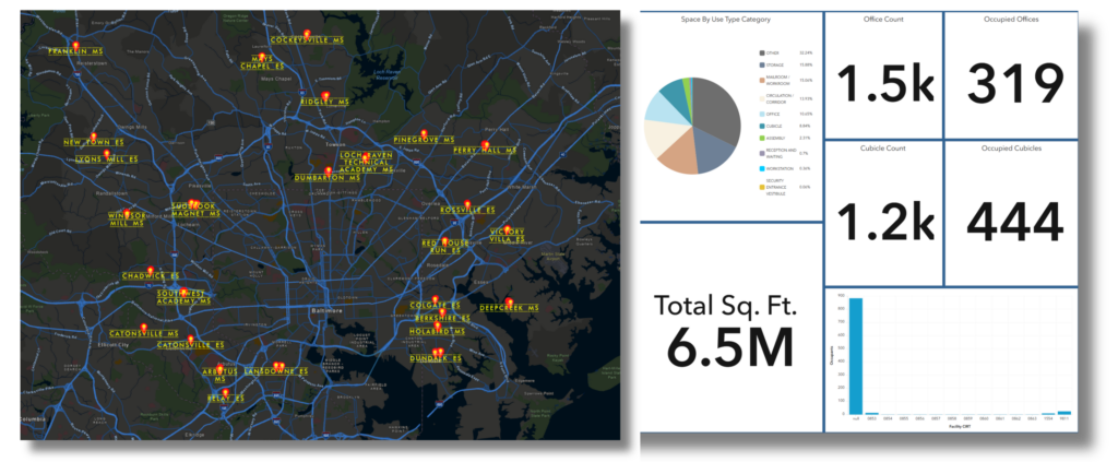
Helping Baltimore County Public Schools (BCPS) Build a Sustainable Indoor GIS Program The Skinny: Goal – Give BCPS an Indoor GIS system serving facilities, security, and emergency response. Partnership – Esri provided the ArcGIS Indoors product, geoConvergence provided CAD conversion, field validation, system integration, and implementation. The Challenge – 176 buildings with CAD files from different vendors/years needed a solution to handle scale and variability Operations-First Approach – Started with administrative facilities (maintenance depots, warehouses) to establish CAD-to-GIS workflows before scaling to school buildings. Field Validation – Physical walkthroughs across 70+ facilities using ArcGIS Field Maps verified CAD data against current conditions, capturing geometry corrections and safety asset updates in real time. Sustainable Program – Multi-year partnership; 2 years in, 5M sq ft digitized across 40+ buildings; ongoing maintenance as buildings and needs evolve. Baltimore County Public Schools (BCPS) needed Indoor GIS across 176 buildings. The challenge converting CAD files and building geodatabases wasn’t just technical. It was operational: creating a system that facilities managers, security personnel, and first responders could rely on. The project is structured as a five-year partnership, which shaped how we prioritize buildings, manage data, and think about long-term maintenance. Two years in, we’ve digitized 5 million square feet and deployed applications across 40+ buildings—including high schools, middle schools, and administrative facilities. Here’s how geoConvergence approached the project and what we’ve learned so far. The Challenge & Approach BCPS had CAD files for most buildings, but they were produced by different vendors across different years and standards. Our job was to standardize these drawings to import them into the ArcGIS Indoors Information Model so indoor data from all facilities could live in a single, consistent system. We processed each CAD file by separating content into standardized layers—rooms, walls, doors, floors, and assets. We then built a semi-automated workflow using ArcGIS Indoors for ArcGIS Pro and ArcPy to convert CAD layers into GIS feature layers with ArcGIS Indoors Information Model-compliant attribution. Because vendor CAD standards varied widely, we automated repeatable steps and performed targeted manual quality assurance/quality control (QA/QC) and made corrections where needed. Field Validation & Mobile Editing CAD-based conversions don’t capture everything. Legacy drawings often miss undocumented renovations, space reconfigurations, and asset changes. To address this, we conducted physical walkthroughs across 70+ facilities to validate the converted indoor data against current conditions. To support this field verification, we integrated ArcGIS Field Maps with ArcGIS Indoors to deploy floor-aware indoor maps in mobile devices. Field staff navigated each level and visually compared mapped features to real-world conditions, while also validating architectural elements (walls, doors, rooms, stairs) and safety assets (AEDs, fire extinguishers, and other emergency equipment). Geometry corrections, asset status verification, and attribute edits were captured in real time and synchronized back to hosted feature layers in ArcGIS Online—streamlining field operations, reducing post-processing, and ensuring verified updates were immediately reflected across the enterprise GIS system. Starting with Operations We didn’t start where you might expect. Before mapping a single school, we delivered 500,000 square feet of indoor data across BCPS operational facilities – maintenance depots, warehouses, and transportation hubs. That decision was deliberate. These facilities gave us a controlled, lower-impact environment to prove the end-to-end CAD-to-GIS workflow standardizing vendor drawings, applying ArcGIS Indoors Information Model attribution, and hardening QA/QC without disrupting student-facing spaces. At the same time, it delivered immediate value to facilities teams through operational workflows like asset management, space utilization, and occupancy planning. By the time we moved to schools, we weren’t piloting anymore—we were scaling a process BCPS had already used, validated, and trusted. Building for Multiple Stakeholders A district-wide Indoor GIS only works if the same authoritative indoor dataset can answer very different questions for very different stakeholders. We built the BCPS Indoors environment to do exactly that: Facilities teams use the system for space utilization and portfolio decisions (including lease avoidance), occupancy planning by linking HR headcount to buildings/spaces, and asset visibility to support day-to-day planning. Safety and operations use floor-aware indoor maps for evacuation planning and for locating and validating critical safety equipment (e.g., AEDs, fire extinguishers, emergency equipment). First responders need rapid access to floor plans by levels, exits, and key asset locations through their emergency management system. We published CAD-derived indoor GIS data to ArcGIS Online as web maps and services, then delivered the applications those teams needed: indoor map viewers, space planning tools, wayfinding/routing networks, and reporting dashboards. Lessons Learned The first years of deployment validated several key decisions: Beginning with administrative facilities established a strong foundation. Testing the workflow for facilities buildings before scaling to schools reduced risk while demonstrating value to facilities teams early. Field validation ensured data accuracy. CAD files rarely reflect current conditions. Physical walkthroughs identified undocumented renovations, relocated assets, and space reconfigurations. Field Maps enabled real-time validation and synchronization, maintaining efficiency at scale. Designing for multiple stakeholders upfront avoided retrofitting later. Facilities needed data integration for occupancy tracking. Emergency responders needed access through their public safety platform. Building these connections from the start meant one dataset serving multiple workflows from the outset. Structuring it as a long-term program supports sustainability. Buildings evolve, and operational needs shift. The multi-year framework accommodates phased deployment and ongoing maintenance, recognizing that Indoor GIS maintains true value when data remains current. For K-12 districts that might be evaluating Indoor GIS at scale, BCPS demonstrates how to build a system that delivers value, scales across an entire district, and remains sustainable over time. The Work Continues This isn’t a one-time deployment. geoConvergence maintains the system and the data, which includes adding new facilities, modifying existing ones, and removing obsolete facilities from the ArcGIS Indoors Information Model. Buildings change, and so do operational needs—the system evolves alongside them. We’re two years into a multi-year timeline, with three more years of phased deployment and continuous maintenance ahead. Phase 2 is ongoing, covering the remaining middle schools and dozens of elementary and special schools. This structure reflects a simple truth: Indoor GIS isn’t a project with an endpoint—it’s a core
geoConvergence recognized as Esri’s 2026 Federal Small Business Specialty Partner of the Year
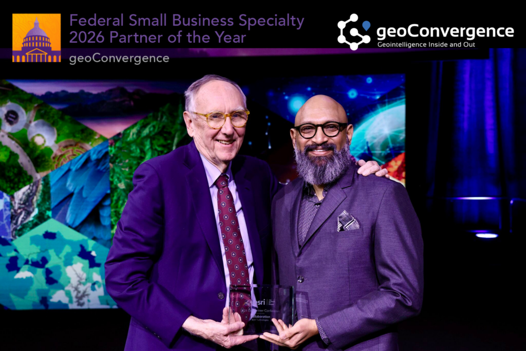
geoConvergence recognized as Esri’s 2026 Federal Small Business Specialty Partner of the Year Washington, DC — February 11, 2026 — geoConvergence is proud to announce it has been named one of two of Esri’s 2026 Federal Small Business Specialty (FSBS) Partner of the Year, the global leader in geographic information system (GIS) technology. The award was presented by Esri President and Founder Jack Dangermond at FedGIS 2026 in Washington, DC, and accepted by geoConvergence Founder & CEO Prem Radhakrishnan. About the Award The Esri Federal Small Business Specialty (FSBS) program, comprised of over 70 Esri business partners, is designed to enhance participant capabilities and readiness to deliver solutions within the federal government space. The program fosters training, growth, and collaboration among partners committed to advancing geospatial technology in service of federal missions. The annual Partner of the Year award recognizes outstanding achievement across four key areas: customer success, technology alignment with federal missions, program participation, and marketing excellence. About the Recognition This honor reflects geoConvergence’s continued commitment to delivering practical, mission-ready geospatial solutions to federal agencies. The company has established itself as a leader in the indoor GIS space, with deep expertise in indoor mapping, ArcGIS Indoors, and digital twin technology. geoConvergence’s solutions enable federal organizations to make operational decisions grounded in real-time facility intelligence — supporting asset management, space planning, and work order execution at scale. This recognition is a reflection of the work the geoConvergence team does every day, and of the trust and partnership of their federal customers. Looking Ahead geoConvergence remains dedicated to advancing the use of geospatial technology across the federal landscape. We are grateful to Esri for this honor, to its federal customers for their continued partnership and trust, and to our team for their expertise and dedication. About geoConvergence Founded in 2004, geoConvergence is a GIS consulting firm specializing in indoor mapping and digital twin solutions for commercial, federal, education and healthcare clients. As an Esri Gold Business Partner with Indoor GIS and Federal Small Business Ready designations, we combine mobile LiDAR technology with GIS expertise to deliver precise spatial data for facility management, wayfinding, and capital planning. geoConvergence serves organizations nationwide requiring secure, accurate indoor mapping solutions.
geoConvergence Partners with Esri on Landmark Digital Twin Project

From point cloud to digital twin: geoConvergence’s mobile LiDAR technology creates comprehensive indoor mapping solutions for healthcare facilities. geoConvergence Partners with Esri on Landmark Digital Twin Project Partnership Delivers Scalable Indoor Mapping Solution for Healthcare Campuses Nationwide Bloomington, Indiana – December, 2025 – geoConvergence, a leader in indoor geospatial solutions, announced a strategic partnership with Esri to deliver comprehensive digital twin technology for a large healthcare campus. The landmark project, currently underway, establishes a scalable framework for healthcare facility modernization that can be replicated across medical centers nationwide. The engagement encompasses +200 buildings totaling over 2.5 million square feet of complex healthcare infrastructure. Using advanced mobile LiDAR scanning and machine learning-powered asset extraction, geoConvergence is creating a comprehensive digital twin that integrates indoor navigation, asset management, and capital planning capabilities on the ArcGIS Indoors platform. The system captures both high-resolution 3D point cloud data and 360-degree panoramic imagery, creating a detailed as-built record of current facility conditions. Modernizing Healthcare Infrastructure The scale and complexity of this engagement reflects the modernization challenges facing aging healthcare infrastructures. With buildings spanning decades of construction and multiple architectural eras, the campus presents the full spectrum of facility management challenges—from space optimization and asset tracking to emergency response planning and accessibility compliance. By developing standardized workflows that combine high-precision spatial data capture with AI-powered processing, geoConvergence and Esri are establishing a framework that can be deployed across healthcare facilities nationwide. The mobile LiDAR approach captures complete facility conditions in weeks rather than the months required by traditional survey methods, while machine learning algorithms accelerate data processing—transforming raw scan data into actionable facility intelligence. A Single Source of Truth for Facility Operations The resulting platform delivers multiple capabilities: real-time indoor wayfinding with ADA-accessible routing for patients and visitors, facilities management tools for maintenance planning and asset tracking, space utilization analytics to optimize building usage, and capital planning data to inform infrastructure investments. All applications draw from a centralized spatial database, ensuring consistency across departments. This centralized approach integrates with existing facility management systems and workflows. By establishing an authoritative spatial dataset, the campus gains a single source of truth for facility information—eliminating data silos and enabling coordinated decision-making across departments. This data governance model ensures long-term sustainability and positions the facility for future technology integration. About geoConvergence Founded in 2004, geoConvergence is a GIS consulting firm specializing in indoor mapping and digital twin solutions for commercial, federal, education and healthcare clients. As an Esri Gold Business Partner with Indoor GIS and Federal Small Business Ready designations, we combine mobile LiDAR technology with GIS expertise to deliver precise spatial data for facility management, wayfinding, and capital planning. geoConvergence serves organizations nationwide requiring secure, accurate indoor mapping solutions. For more information, visit www.geoconvergence.com
Press Release – geoConvergence is now an Esri Gold Partner in the Esri Partner Network
geoConvergence is now an Esri Gold Partner in the Esri Partner Network
geoConvergence Earns Esri ArcGIS Indoors Specialty Designation

Geographic Information Systems (GIS) Company Receives Designation for Indoor Mapping Technology Contract Work at NSWC Crane Was Critical in Achieving this Esri Designation Odon, IN – March 25, 2021″ geoConvergence, an SBA 8(a) Certified Small Business, earned Esri’s ArcGIS Indoors Specialty designation in recognition of their knowledge and expertise in indoor mapping for use in creating connected workspaces. GIS incorporates geographical features to map, analyze and assess real-world problems. ArcGIS Indoors can be used to map and analyze the interiors of office buildings, warehouses and other structures for a variety of commercial and government purposes. “We’re honored to be among a handful of Esri Partner Network companies to earn this designation,” said Prem Radhakrishnan, geoConvergence co-founder and CEO. “The demand for indoor mapping technology continues to grow exponentially and our partnership with Esri allows us to help customers modernize their workplace operations and create smart buildings for efficient workforce and space management.” In 2020, Naval Surface Warfare Center (NSWC) Crane’s Global Deterrence and Defense (GX) Department awarded geoConvergence an SBA 8(a) Direct Award contract to provide indoor mapping of a 150,000 square foot structure using ArcGIS Indoors. Capabilities such as space management, scenario modeling, and asset tracking were included in the solution. The GX Department at NSWC Crane was instrumental in geoConvergence attaining the Esri Indoors Specialty designation. NSWC Crane also leveraged the SBA’s 8(a) program that allowed them to shorten the contracting life cycle from possibly years to days/months. Firms certified in the SBA 8(a) program are eligible for receiving direct contract awards from the Federal Government to ease the burden of contracting and help small businesses grow. “We’re grateful to the leadership at NSWC Crane that engage with a small business like geoConvergence,” explained Radhakrishnan. “Opportunities like this help both the government obtain critical services while enabling small, disadvantaged businesses to make meaningful contributions and to grow.” About geoConvergence:geoConvergence is an SBA 8(a) certified, minority-owned small business. The firm specializes in the design and implementation of world-class Geospatial Intelligence, Geographic Information Systems (GIS), and Space Management solutions by leveraging technical skills in Software Development, Cloud Engineering, and Data Analytics required to create secure, effective, efficient, and resilient solutions in today’s highly connected network environment. geoConvergence has also earned the following Esri Specialties: Release Ready, Federal Small Business, and ArcGIS Online. For more information, visit https://geoConvergence.com. Tweet