
From Parcels to Pixels: What the 90s Mapping Boom Teaches Us About Today’s Digital Twins
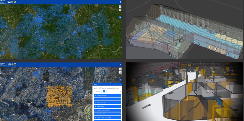
From Parcels to Pixels: What the 90s Mapping Boom Teaches Us About Today’s Digital Twins A comparison of parcel mapping’s rise in the 1990s–2000s and the indoor digital twin revolution today By: Prem Radhakrishnan, President & CEO, geoConvergence LLC Introduction If you worked in GIS in the 1990s or early 2000s, you probably remember the race to digitize parcel maps. Counties and cities were converting paper tax maps into digital formats—often under pressure from assessors, tax collectors, and planners who needed faster, more reliable access to land records. At first, these parcel datasets were fragmented—built for a single department, stored in isolated systems, and rarely aligned with other sources of truth. Over time, however, parcel mapping evolved from static datasets into integrated land information systems. Parcel boundaries became the spatial backbone for connecting assessment records, tax data, zoning, ownership, permits, and more. Today, we’re seeing a similar shift—this time inside buildings. Digital twins and indoor mapping are turning rooms, corridors, and assets into the shared spatial framework that integrates operations, safety, navigation, and analytics. Then: Parcel Maps Became the Backbone of Land Information Systems Early parcel mapping efforts were often driven by taxation: digitize parcel boundaries and link them to assessment rolls. But once GIS investment increased, the parcel layer quickly became useful far beyond the assessor’s office. Parcel layers became the common index across departments: Assessors linked valuation and ownership records Tax offices tied billing and payment histories Planning departments layered zoning and land use Public works connected infrastructure inventories and permits Clerks and recorders improved search, retrieval, and transparency of land records What started as a mapping project became an enterprise platform. The parcel identifier became a shared key, enabling interoperability—often before modern APIs and cloud platforms made integration straightforward. Common Challenges (1990s–2000s) Inconsistent parcel identifiers and boundary discrepancies across departments Slow update cycles and unclear stewardship for edits Legacy systems that resisted integration Governance issues: who owns the “source of truth”? Cultural silos: departments optimized for their own workflows Now: Indoor Mapping Is Becoming the Foundation of Digital Twins Indoor mapping and digital twin initiatives now follow a similar trajectory—often faster, with higher expectations. Organizations are mapping rooms, corridors, and assets across hospitals, campuses, airports, and corporate real estate portfolios. Many programs begin with a single primary need: Wayfinding and visitor experience Space planning and utilization (workplace analytics) Facilities maintenance and asset inventory But like parcel mapping before it, indoor mapping becomes far more valuable when it serves as a shared spatial index—connecting multiple systems across the enterprise. Modern digital twins increasingly integrate: AM/FM and CMMS systems (assets, work orders, preventive maintenance) IoT sensors (occupancy, temperature, air quality, energy use) Wayfinding and navigation applications Public safety and emergency response (preplans, muster points, evacuation routing) Security and access systems (doors, zones, permissions) Sustainability reporting and operational performance dashboards The Parallels Are Strong Across both eras, the pattern repeats: Single-purpose mapping evolves into multi-system integration A shared spatial index emerges (parcel ID then; room/space + asset IDs now) Silos give way—slowly—to interoperability Governance becomes central as more systems depend on shared spatial truth Value grows exponentially as integrations compound What’s Different Today: Speed, Real-Time Data, and 3D Expectations Faster adoption cycles due to cloud platforms, APIs, and modern integration tooling Dynamic, real-time data streams (IoT, events, telemetry) rather than mostly static records Higher UX expectations: mobile-first, intuitive search, and consumer-grade wayfinding 3D/4D context: floors, vertical circulation, and time-based simulation/prediction Lessons from the Parcel Mapping Era for Digital Twins Parcel mapping’s long arc offers practical guidance for indoor digital twins—especially on standards, governance, and integration design. Define a consistent spatial framework early (spaces/rooms as the “parcel” equivalent) Treat identifiers as first-class: stable IDs for buildings, floors, rooms, and assets Establish data stewardship and update workflows before scaling Design for integration (systems of record) rather than visualization alone Measure platform value over time: integrations, reduced response time, improved service, lower operating costs Conclusion In the 1990s and 2000s, parcel mapping helped unify how organizations understand and manage land—turning disconnected records into integrated platforms. Today, indoor mapping and digital twins are poised to do the same for the built environment—connecting rooms and assets to maintenance, wayfinding, public safety, and operational intelligence. That parcel-era pattern is part of our own history. Our Elevate platform grew out of exactly this kind of work—helping local governments unify land records, ownership data, tax information, and infrastructure into a single spatial framework accessible to the public. What started as a mapping tool scaled into a shared platform with over 100,000 registered users pulling from multiple integrated data sources across county departments. We worked on foundation spatial frameworks and designed the architecture supporting the web application that turned fragmented departmental records into a connected land information system. We’ve carried that same integration philosophy indoors. For the Department of Veterans Affairs Central Office, we built the Space Management Support System (SMSS)—scanning and modeling over one million square feet across 14 facilities, converting floor plans into intelligent GIS layers, and connecting space data to asset management, personnel, and equipment systems. The result was a platform that let VACO visualize occupancy, identify underutilized space, and make data-driven decisions about their real estate portfolio. Today, our Scan2Twin workflows replace manual field measuring with automated, multi-modal data capture. The tools are more advanced and the pace is faster, but the core idea is unchanged: when you organize data around space, everything else starts to connect. Reach out for more info@geoconvergence.com and connect with us on LinkedIn.
Seat-Level Digital Twins: Scaling ArcGIS Indoors and Public Safety for Multi-Tiered Arenas
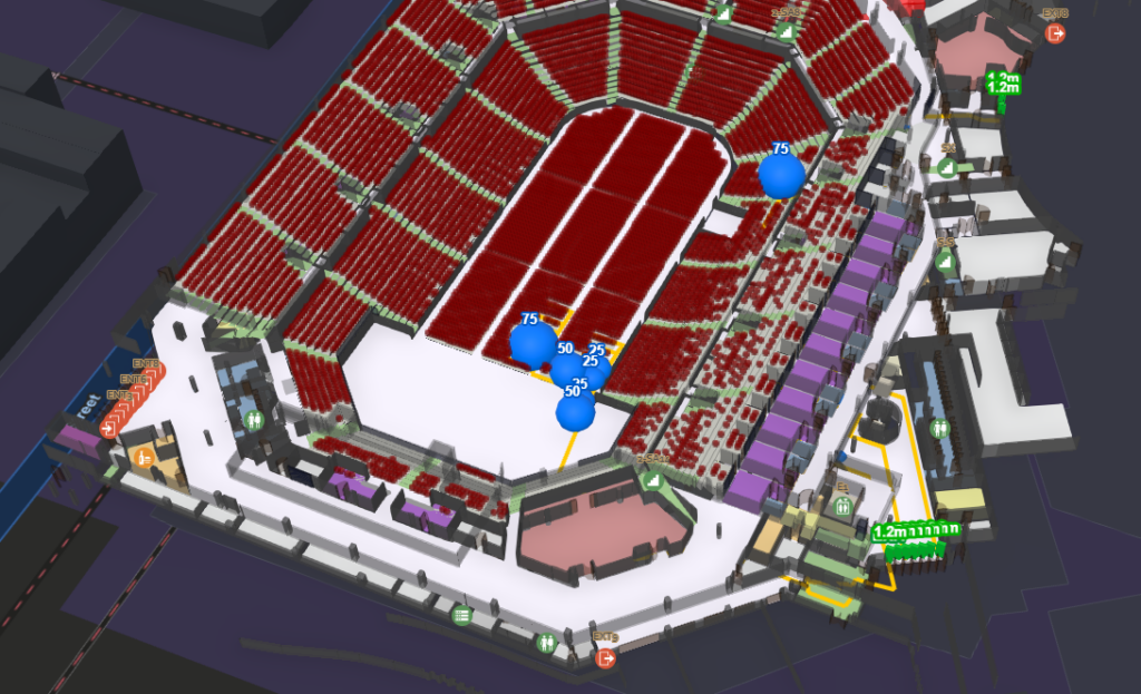
Seat-Level Digital Twins: Scaling ArcGIS Indoors and Public Safety for Multi-Tiered Arenas The Skinny Goal: Bring 93 municipal buildings and the 260,000 sq. ft. Dignity Health Arena into a single ArcGIS Enterprise environment. The Challenge: 2D floor plans fail when applied to the overlapping concourses and sloped seating bowls of a massive entertainment venue. The Approach: Captured the arena with mobile LiDAR, processed it into a Revit BIM model, and fed it directly into an ArcGIS Indoors network. Public Safety: The routing-aware spatial data powers S/Planner, allowing security teams to simulate evacuations and spot bottlenecks without disrupting daily operations. From City Blocks to the Arena Floor The City of Bakersfield’s Technology Services Division set out to modernize how it manages and navigates its facilities portfolio — spanning 93 city buildings and one of its most complex venues, the 260,000 sq. ft. Dignity Health Arena. The goal: a unified indoor mapping platform capable of supporting operations, wayfinding, and future smart-facility initiatives. Working with geoConvergence, the project team implemented the ArcGIS Indoors Information Model across the City’s facilities and deployed ArcGIS Indoors within a production ArcGIS Enterprise environment. For most sites, existing GIS-based floor plan datasets were migrated through CAD into the Indoors information model. The Dignity Health Arena, however, required a different approach. Unlike standard buildings with flat floors and predictable hallways, the arena is a massive, continuous volume and accurately representing that physical reality inside the City’s GIS demanded a true digital twin. The Anatomy of an Arena When looking at the physical makeup of a stadium, it becomes obvious why standard indoor mapping methods break down. An arena is a layered, highly complex structure designed to move thousands of people at once. There are restricted access zones for talent and staff, alongside VIP tiers with dedicated elevators. Wide vendor concourses intersect with steep, sloped seating bowls, creating constantly overlapping pathways. A 2D floor plan cannot accurately represent a staircase that cuts through three different zones, nor can it map the line of sight from a security checkpoint to a specific seating section. Flattening a stadium onto a piece of paper or a standard CAD file completely removes the spatial context required to manage the building. Why Spatial Clarity Matters Relying on legacy CAD files keeps facility teams anchored to static reference drawings. When managing a complex building, 2D maps simply fail to provide the necessary spatial context for efficient daily operations. ArcGIS Indoors transforms this static data into an active operational engine. By establishing true spatial clarity, facility managers gain an intelligent, routing-aware network. Instead of spending time navigating layered mechanical spaces to find an asset, field workers are routed straight to their target, turning an accurate 3D map into an immediate operational advantage. Engineering the Space Capturing this level of detail meant bypassing legacy floor plans entirely. Our field team scanned the entire arena with mobile LiDAR, capturing the exact, current conditions of the building. That point cloud was converted into a highly detailed Revit model, establishing the structural framework, the concourses, and the tiered seating. That 3D model then served as the direct source for the ArcGIS Indoors dataset. Instead of mapping massive seating sections as solid, un-routable blocks, we modeled every single seating row as an individual room unit polygon. The resulting map creates a continuous routing network that guides a user from a specific exterior gate, through the interior corridors, and directly to a single seat. Built for Public Safety When spatial data reaches this level of accuracy, it becomes the foundational geometry for public safety and scenario planning. Knowing the layout of the concourse is helpful; knowing exactly how crowds will move through it during an evacuation saves lives. Because the indoor map is routing-aware, it feeds directly into S/Planner, geoConvergence’s proprietary emergency scenario simulator. This allows security directors to use the 3D model to run virtual evacuation drills and watch groups move through the digital twin. The software tracks the analytics — measuring cumulative egress over time and calculating exactly how long it takes a crowd to clear a specific section. It immediately highlights physical bottlenecks in stairwells or corridors before an event ever takes place. Most importantly, safety teams can run a hundred different virtual scenarios without ever having to close the arena or conduct a physical drill. https://youtu.be/bjoKlRXUkF8 A Single Pane of Glass The success of the Dignity Health Arena project goes beyond the walls of the stadium itself. The true achievement for the City of Bakersfield is the portfolio-wide integration. Whether a city planner needs to check the space utilization of a standard 3rd-floor HR office downtown, or a security director needs to review the egress route from a seat in the upper bowl of the arena, they do it in the exact same system. By converting 93 municipal buildings and a complex venue into the ArcGIS Indoors Information Model, the city achieved a single pane of glass for their entire facility portfolio. They no longer have to jump between disconnected software platforms or dig through paper archives. The data is centralized, routing-aware, and ready to support everything from daily maintenance to life-saving emergency response.
geoConvergence Recognized as an Esri Cornerstone Partner for 20 Years of Commitment to Esri and ArcGIS Software

geoConvergence Recognized as an Esri Cornerstone Partner for 20 Years of Commitment to Esri and ArcGIS Software Bloomington, Indiana – March 9, 2026, at 9:00 AM PST – geoConvergence was recognized as a Cornerstone Partner at the 2026 Esri Partner Conference (EPC) held March 8-9, 2026 in Palm Springs, California. This acknowledgment was presented to geoConvergence for their long-term commitment to Esri and the geographic information system (GIS) community. Cornerstone Partner recognition is given to organizations that have participated in the Esri Partner Network (EPN) for 20 years while demonstrating a consistent focus on helping customers succeed through the adoption of ArcGIS software. For over two decades, geoConvergence has delivered end-to-end GIS solutions that transform how organizations understand and manage their physical spaces. From mobile LiDAR capture and survey-grade 3D scanning to digital twin creation, enterprise GIS architecture, and custom ArcGIS development, geoConvergence provides the full spectrum of indoor mapping expertise powered by ArcGIS Indoors and ArcGIS Enterprise to help organizations improve facility management, streamline operations, and make smarter, data-driven decisions. Recognized multiple times by Esri for innovation and excellence, geoConvergence continues to advance the future of indoor spatial intelligence, helping organizations navigate the growing demand for smarter, more connected built environments. geoConvergence is honored to be recognized by Esri as a Cornerstone Partner. This acknowledgment reflects our team’s enduring commitment to delivering precise, innovative GIS solutions and our dedication to the clients and communities we serve. About geoConvergencegeoConvergence provides high-end GIS implementation and integration services. Since 2004, we have specialized in extending Esri technology to solve complex spatial data challenges for federal, state, and commercial organizations. Our end-to-end approach covers the full project lifecycle — from initial architecture and cloud engineering to long-term system maintenance. As an Esri Gold Business Partner with Indoor GIS and Federal Small Business Ready designations, geoConvergence brings specialized expertise and a proven track record of helping organizations succeed through the adoption of ArcGIS technology. Media Contact Info:geoConvergence642 N Madison St, Bloomington, IN 47404📞 (855) 447–3939✉️ info@geoConvergence.com🌐 www.geoconvergence.com
geoConvergence recognized as Esri’s 2026 Federal Small Business Specialty Partner of the Year

geoConvergence recognized as Esri’s 2026 Federal Small Business Specialty Partner of the Year Washington, DC — February 11, 2026 — geoConvergence is proud to announce it has been named one of two of Esri’s 2026 Federal Small Business Specialty (FSBS) Partner of the Year, the global leader in geographic information system (GIS) technology. The award was presented by Esri President and Founder Jack Dangermond at FedGIS 2026 in Washington, DC, and accepted by geoConvergence Founder & CEO Prem Radhakrishnan. About the Award The Esri Federal Small Business Specialty (FSBS) program, comprised of over 70 Esri business partners, is designed to enhance participant capabilities and readiness to deliver solutions within the federal government space. The program fosters training, growth, and collaboration among partners committed to advancing geospatial technology in service of federal missions. The annual Partner of the Year award recognizes outstanding achievement across four key areas: customer success, technology alignment with federal missions, program participation, and marketing excellence. About the Recognition This honor reflects geoConvergence’s continued commitment to delivering practical, mission-ready geospatial solutions to federal agencies. The company has established itself as a leader in the indoor GIS space, with deep expertise in indoor mapping, ArcGIS Indoors, and digital twin technology. geoConvergence’s solutions enable federal organizations to make operational decisions grounded in real-time facility intelligence — supporting asset management, space planning, and work order execution at scale. This recognition is a reflection of the work the geoConvergence team does every day, and of the trust and partnership of their federal customers. Looking Ahead geoConvergence remains dedicated to advancing the use of geospatial technology across the federal landscape. We are grateful to Esri for this honor, to its federal customers for their continued partnership and trust, and to our team for their expertise and dedication. About geoConvergence Founded in 2004, geoConvergence is a GIS consulting firm specializing in indoor mapping and digital twin solutions for commercial, federal, education and healthcare clients. As an Esri Gold Business Partner with Indoor GIS and Federal Small Business Ready designations, we combine mobile LiDAR technology with GIS expertise to deliver precise spatial data for facility management, wayfinding, and capital planning. geoConvergence serves organizations nationwide requiring secure, accurate indoor mapping solutions.
Press Release – geoConvergence is now an Esri Gold Partner in the Esri Partner Network
geoConvergence is now an Esri Gold Partner in the Esri Partner Network