Digital Twin: A geoConvergence Story
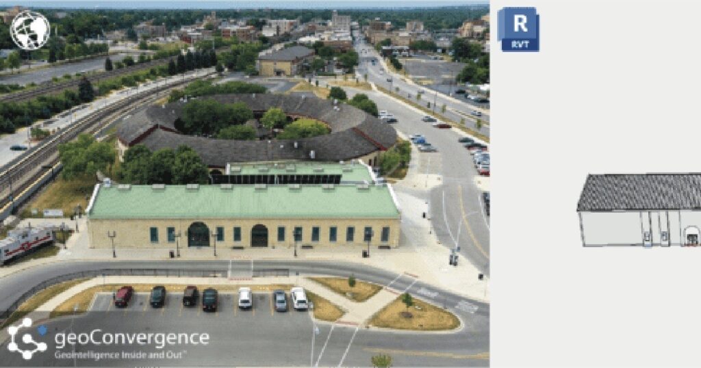
What is a Digital Twin? A digital twin is an accurate model of a real world building. The process for generating these models integrates data from various sources, such as building management systems, IoT sensors, and spatial information, to provide real-time insights into the indoor environment. This digital representation allows for enhanced visualization, analysis, and management of spaces, helping users optimize space utilization, streamline operations, and improve facility management through accurate, up-to-date information and simulations. Shaping the Future: The Impact of Digital Twins The integration of digital twins in ArcGIS Indoors is significantly shaping the future of the industry by transforming how indoor spaces are managed, analyzed, and optimized. Here’s how: Digital twins in ArcGIS Indoors provide a comprehensive, real-time virtual model of indoor environments. This allows organizations to manage and optimize space usage more effectively by visualizing and analyzing spatial data, which aids in everything from layout adjustments to strategic space planning. By integrating real-time data from various sources (like IoT sensors and building management systems) into a digital twin, facility managers can monitor building systems, track asset performance, and detect issues before they escalate. This proactive approach enhances operational efficiency and reduces downtime and maintenance costs. ArcGIS Indoors combines digital twins with advanced GIS capabilities, enabling detailed spatial analysis and data integration. This integration allows for sophisticated simulations and modeling, such as predicting how changes in one part of a building affect other areas, or assessing the impact of new developments. Digital twins improve user experience by providing interactive, user-friendly interfaces for navigating indoor spaces. For example, they can help with indoor navigation, optimize the placement of resources and services, and improve accessibility for building occupants. Our Digital Twin Solution geoConvergence has developed a refined process for data collection, model creation, and indoor feature services to provide an all inclusive facility management solution. No matter your starting point, we can provide a robust digital twin combined with the power of GIS tailored to your specific needs. Complete with your choice of wayfinding, space management, asset management, safety scenario planning, or a combination of these to improve operational efficiency. Our team of qualified team members works efficiently to create, improve and innovate these processes to deliver top of the line results. This speaks to the abilities of each member and their commitment to delivering the best results for our clients. With products like Autodesk Revit and Esri’s ArcGIS Indoors, we can bring to life what once was only a snapshot in time. Just a few years ago, it would seem impossible to be able to create a 1:1 digital model with all of these capabilities. Advancements in data conversion technology have improved the turnaround time for data collection and digital representation. We can now generate these models with more accuracy and efficiency than ever before. geoConvergence is committed to exploring these advances in technology to push the boundaries of what is possible.
Press Release – geoConvergence is now an Esri Gold Partner in the Esri Partner Network
geoConvergence is now an Esri Gold Partner in the Esri Partner Network
geoConvergence Earns Esri ArcGIS Indoors Specialty Designation

Geographic Information Systems (GIS) Company Receives Designation for Indoor Mapping Technology Contract Work at NSWC Crane Was Critical in Achieving this Esri Designation Odon, IN – March 25, 2021″ geoConvergence, an SBA 8(a) Certified Small Business, earned Esri’s ArcGIS Indoors Specialty designation in recognition of their knowledge and expertise in indoor mapping for use in creating connected workspaces. GIS incorporates geographical features to map, analyze and assess real-world problems. ArcGIS Indoors can be used to map and analyze the interiors of office buildings, warehouses and other structures for a variety of commercial and government purposes. “We’re honored to be among a handful of Esri Partner Network companies to earn this designation,” said Prem Radhakrishnan, geoConvergence co-founder and CEO. “The demand for indoor mapping technology continues to grow exponentially and our partnership with Esri allows us to help customers modernize their workplace operations and create smart buildings for efficient workforce and space management.” In 2020, Naval Surface Warfare Center (NSWC) Crane’s Global Deterrence and Defense (GX) Department awarded geoConvergence an SBA 8(a) Direct Award contract to provide indoor mapping of a 150,000 square foot structure using ArcGIS Indoors. Capabilities such as space management, scenario modeling, and asset tracking were included in the solution. The GX Department at NSWC Crane was instrumental in geoConvergence attaining the Esri Indoors Specialty designation. NSWC Crane also leveraged the SBA’s 8(a) program that allowed them to shorten the contracting life cycle from possibly years to days/months. Firms certified in the SBA 8(a) program are eligible for receiving direct contract awards from the Federal Government to ease the burden of contracting and help small businesses grow. “We’re grateful to the leadership at NSWC Crane that engage with a small business like geoConvergence,” explained Radhakrishnan. “Opportunities like this help both the government obtain critical services while enabling small, disadvantaged businesses to make meaningful contributions and to grow.” About geoConvergence:geoConvergence is an SBA 8(a) certified, minority-owned small business. The firm specializes in the design and implementation of world-class Geospatial Intelligence, Geographic Information Systems (GIS), and Space Management solutions by leveraging technical skills in Software Development, Cloud Engineering, and Data Analytics required to create secure, effective, efficient, and resilient solutions in today’s highly connected network environment. geoConvergence has also earned the following Esri Specialties: Release Ready, Federal Small Business, and ArcGIS Online. For more information, visit https://geoConvergence.com. Tweet
ArcGIS Indoors

geoConvergence has successfully deployed ArcGIS Indoors for a facility and asset management project for the Global Deterrence and Defense Department of the Naval Surface Warfare Center at Crane. This project involved an enterprise implementation of Esri’s new ArcGIS Indoors platform and has improved the staff’s ability to visualize and understand their workplace environment and optimize the use of available space.