Digital Twin: A geoConvergence Story
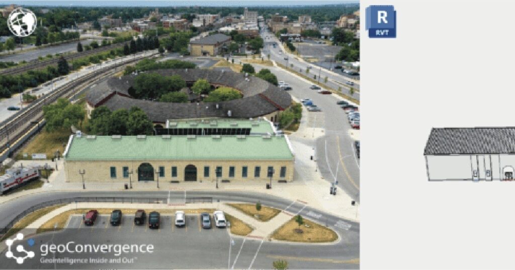
What is a Digital Twin? A digital twin is an accurate model of a real world building. The process for generating these models integrates data from various sources, such as building management systems, IoT sensors, and spatial information, to provide real-time insights into the indoor environment. This digital representation allows for enhanced visualization, analysis, and management of spaces, helping users optimize space utilization, streamline operations, and improve facility management through accurate, up-to-date information and simulations. Shaping the Future: The Impact of Digital Twins The integration of digital twins in ArcGIS Indoors is significantly shaping the future of the industry by transforming how indoor spaces are managed, analyzed, and optimized. Here’s how: Digital twins in ArcGIS Indoors provide a comprehensive, real-time virtual model of indoor environments. This allows organizations to manage and optimize space usage more effectively by visualizing and analyzing spatial data, which aids in everything from layout adjustments to strategic space planning. By integrating real-time data from various sources (like IoT sensors and building management systems) into a digital twin, facility managers can monitor building systems, track asset performance, and detect issues before they escalate. This proactive approach enhances operational efficiency and reduces downtime and maintenance costs. ArcGIS Indoors combines digital twins with advanced GIS capabilities, enabling detailed spatial analysis and data integration. This integration allows for sophisticated simulations and modeling, such as predicting how changes in one part of a building affect other areas, or assessing the impact of new developments. Digital twins improve user experience by providing interactive, user-friendly interfaces for navigating indoor spaces. For example, they can help with indoor navigation, optimize the placement of resources and services, and improve accessibility for building occupants. Our Digital Twin Solution geoConvergence has developed a refined process for data collection, model creation, and indoor feature services to provide an all inclusive facility management solution. No matter your starting point, we can provide a robust digital twin combined with the power of GIS tailored to your specific needs. Complete with your choice of wayfinding, space management, asset management, safety scenario planning, or a combination of these to improve operational efficiency. Our team of qualified team members works efficiently to create, improve and innovate these processes to deliver top of the line results. This speaks to the abilities of each member and their commitment to delivering the best results for our clients. With products like Autodesk Revit and Esri’s ArcGIS Indoors, we can bring to life what once was only a snapshot in time. Just a few years ago, it would seem impossible to be able to create a 1:1 digital model with all of these capabilities. Advancements in data conversion technology have improved the turnaround time for data collection and digital representation. We can now generate these models with more accuracy and efficiency than ever before. geoConvergence is committed to exploring these advances in technology to push the boundaries of what is possible.
Mapping Facilities and Assets inside the Hospital
Mapping Facilities and Assets inside the Hospital A custom GIS application at the University of Kentucky (UK) now supports occupancy of the 16-floor, 1.2-million-square-foot Level 1 Trauma Center, called UK Chandler Hospital Pavilion A. Maps and room data sheets detail each room along with occupancy and accompanying assets including furniture, medical equipment, and technologies. Built on an ArcGIS platform, the application was developed by Michelle Ellington, UK GIS coordinator, and Andrew Blues, UK information technology manager, along with 39°N, an Esri business partner. “We have a lot of information silos, but this application will serve to analyze all that data in one centralized location,” Ellington said. “We chose GIS because it is a scalable solution for integrating data types and university-wide systems.” Custom enhancements include the integration of CAD drawings, room data sheet generation, 360-degree panoramic pictures of rooms both fitted and in the predrywall stage, on-the-fly symbolization, Web site linking, and a powerful asset editing module. The system is being expanded to integrate other campuswide systems and support additional university needs. “We built the custom ArcGIS Server application using the Flex API to maximize accessibility and ease of use,” said Chris Walls, cofounder of 39°N. “We are extremely proud of this cutting-edge collaboration with the University of Kentucky. This kind of application will significantly streamline the administration of public facilities.” For more information, visit 39degreesnorth.com and esri.com/health or contact Michelle Ellington at michelle.ellington@uky.edu. Link to original article: ArcNews healthyGIS Winter 2010/2011