
Mapping Facilities and Assets inside the Hospital

Mapping Facilities and Assets inside the Hospital A custom GIS application at the University of Kentucky (UK) now supports occupancy of the 16-floor, 1.2-million-square-foot Level 1 Trauma Center, called UK Chandler Hospital Pavilion A. Maps and room data sheets detail each room along with occupancy and accompanying assets including furniture, medical equipment, and technologies. Built on an ArcGIS platform, the application was developed by Michelle Ellington, UK GIS coordinator, and Andrew Blues, UK information technology manager, along with 39°N, an Esri business partner. “We have a lot of information silos, but this application will serve to analyze all that data in one centralized location,” Ellington said. “We chose GIS because it is a scalable solution for integrating data types and university-wide systems.” Custom enhancements include the integration of CAD drawings, room data sheet generation, 360-degree panoramic pictures of rooms both fitted and in the predrywall stage, on-the-fly symbolization, Web site linking, and a powerful asset editing module. The system is being expanded to integrate other campuswide systems and support additional university needs. “We built the custom ArcGIS Server application using the Flex API to maximize accessibility and ease of use,” said Chris Walls, cofounder of 39°N. “We are extremely proud of this cutting-edge collaboration with the University of Kentucky. This kind of application will significantly streamline the administration of public facilities.” For more information, visit 39degreesnorth.com and esri.com/health or contact Michelle Ellington at michelle.ellington@uky.edu. Link to original article: ArcNews healthyGIS Winter 2010/2011
ArcGIS Infrastructure Migration for the Indiana Geographic Information Office

ArcGIS Infrastructure Migration for the Indiana Geographic Information Office About Indiana Geographic Information Office (GIO)The GIS Office contributes to the quality of Indiana as a place to live and work by cultivating statewide geographic information resources (relationships, data and technology) so that individuals and organizations across the state have suitable access to accurate and relevant geographic information and technology. The ChallengeFor well over a decade, Indiana’s Geographic Information Office has managed a library of over 300 geospatial datasets for access and use by state government employees and the public. The infrastructure that supported the library consisted of two on-site ESRI ArcGIS servers that were load balanced with Oracle as the database backend. Datasets were accessed via hundreds of services. The servers had to be provisioned with high enough virtual memory to be able to host the large number of services. This combined with the high volume of traffic was pushing the limits of the existing hardware. In addition, connectivity was cumbersome for users who were required to access the library via Virtual Private Network (VPN) technology. The SolutionThe state wanted an alternate solution that would be scalable, cost-effective, and allow users to connect securely to the data and services from any location without using VPN. Collectively, these challenges strongly favored a solution that would migrate the infrastructure to the cloud and resolve issues related to: Scalability.The load on the servers varies through the day and week. An autoscaling environment provides both cost and performance optimization. Accessibility.Users needed to connect to ArcGIS Enterprise securely using State credentials and single sign-on access protocols without VPN. Performance.The burden on ArcGIS server could be reduced by offloading processing and employing ArcGIS Datastore. Security.The solution should allow implementing SSO with the existing Azure AD in use by the State. Capacity.Avoiding the overprovisioning of machines by using a tiered architecture with independent scaling. geoConvergence designed a cloud infrastructure to overcome these challenges and meet future needs such as: collaborations with various state agencies, the deployment of an open data portal using ArcGIS Hub and the eventual realization of a “system of systems” promoted by Esri’s visionary leader, Jack Dangermond. Working closely with the GIO, the architecture was designed not only to be scalable but also highly available and resilient. geoConvergence used CloudFormation templates to automate the deployment of the various ArcGIS Enterprise infrastructure components which were specifically architected for the AWS Cloud. ArcGIS Enterprise was then connected to the Azure AD for security and single sign-on access. A close examination of user workflows identified the opportunity to streamline operations by removing Oracle and the enterprise geodatatabase from the architecture and employing an ArcGIS Data Store and hosted feature layers instead. Additional performance was gained by implementing distributed and partner collaborations to avoid duplication of data that were already published by collaborating agencies. Ultimately, geoConvergence was able to partner with the GIO’s office to create a versatile and efficient ArcGIS Enterprise platorm that is secure and scalable. “The State of Indiana needed to modernize our system of data hosting and delivery to take advantage of the latest technologies and capabilities that align with the longterm strategic vision. The first step was migrating our GIS Infrastructure to the AWS Cloud, laying the foundation to establish a secure and scalable platform for the future.” Megan Compton, State of Indiana GIOgio@iot.in.gov
geoConvergence Earns Certified HUBZone Small Business Status
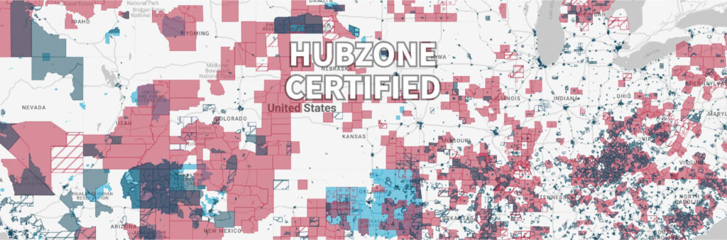
geoConvergence Earns Certified HUBZone Small Business Status U.S. Government program will provide an advantage to geoConvergence when pursuing federal contracts (Bloomington, IN – July 6, 2022) geoConvergence, a best-in-class provider of geospatial intelligence and Information Technology (IT) consulting services, is pleased to announce that the company has received the HUBZone (Historically Underutilized Business Zone) certification from the U.S. Small Business Administration (SBA). The SBA certified geoConvergence as a “qualified HUBZone small business concern.” The company is now eligible to receive HUBZone contracting opportunities and will be included in the listing of SBA-qualified HUBZone small business concerns. The SBA HUBZone program, designed to limit competition for certain government contracts to businesses in historically underutilized business zones, gives preferential consideration to those businesses in full and open competition. As a HUBZone certified company with a Small Disadvantaged Business designation, geoConvergence has access to federal set-aside and sole-source contracts, which in turn advances the federal government’s effort to spur economic growth in economically challenged areas. These preferences go to small businesses that obtain HUBZone certification in part by employing staff who live in a HUBZone. “geoConvergence is thrilled to be certified by the SBA in their HUBZone program,” said Prem Radhakrishnan, Co-Founder and CEO. “As an Indiana-based IT company pursuing federal contracts, this certification will allow us to help federal procurement officers achieve their set-aside targets, while also supporting economic development in the historically underutilized business zones in the country.” About geoConvergenceSince 2004, geoConvergence has specialized in implementing, integrating, and extending core Esri technology. geoConvergence is an award-winning, SBA 8(a) and HUBZone Certified Small Business providing best-in-class solutions to commercial and government customers. geoConvergence has won three Special Achievement in GIS (SAG) awards from Esri for our creative geospatial solutions and services. In March 2022, geoConvergence won an Esri Partner Award for System Implementation. This award was a result of geoConvergence’s continued demonstration of innovative ways to solve complex problems by using Esri’s ArcGIS software and exceptional work in advancing geographic information systems (GIS) technology. Media contact: Chris Wallschris@geoconvergence.com(812) 320-5467
geoConvergence Receives System Implementation Award at Esri Partner Conference for Exceptional Achievement

geoConvergence Receives System Implementation Award at Esri Partner Conference for Exceptional Achievement geoConvergence was one of 26 Esri partners that received an achievement award at the conference. (Palm Springs, CA – March 6, 2022) geoConvergence received the System Implementation Award at the 2022 Esri Partner Conference (EPC) held in Palm Springs, California March 5–7, 2022. This award was presented to geoConvergence for ensuring customer success through comprehensive implementation of the ArcGIS system. “Esri congratulates geoConvergence on their 2022 EPC award in recognition of their innovative work leveraging ArcGIS software,” said Robert Laudati, Director of Global Partners and Alliances at Esri. “We are proud to partner with geoConvergence to foster the use of GIS technology in support of our mutual customers.” geoConvergence specializes in implementing, integrating, and extending core Esri technology and has been a trusted Esri partner for nearly two decades. “We are humbled and proud to receive this recognition from Esri,” said Prem Radhakrishnan, geoConvergence co-founder and CEO. “This validates the years of hard work our team has put in to ensuring we exceed our customers’ and partners’ expectations.” geoConvergence has earned the System Implementation Award for working with the Indiana Election Division in modernizing their entire reprecincting process using ArcGIS Enterprise. Indiana Election Division is responsible for the voting districts and precincts for the State of Indiana. Their responsibilities also include aiding the local election agencies in the reprecincting process. geoConvergence worked with the State of Indiana to develop a Statewide Election Support System that fully integrates with their existing Voter Registration System and streamlines the process of reprecincting by providing tools to the local and state officials to validate voter addresses, manage annexations, create precincts and validate the precincts for election code compliance. This was achieved through the use of ArcGIS Enterprise by leveraging named users, groups and branched versioning. Esri is the global leader in location intelligence with a network of over 2700 partners around the world. The award winners are organizations that have demonstrated innovative and creative ways to solve complex problems by using Esri’s ArcGIS software and those who have done exceptional work in advancing geographic information systems (GIS) technology. geoConvergence was one of 26 Esri partners that received an achievement award at the conference. “The election system has come under increasing scrutiny in recent years. Leveraging Esri technology, we created a system and process that allows for greater accountability, visibility and transparency into how precincts are created,” said Radhakrishnan. “It is critical to incorporate GIS into the election process from the bottom up and to include geocoding of voter addresses to ensure precincts meet legal requirements, with precise political boundaries” About EsriEsri, the global market leader in geographic information system (GIS) software, location intelligence, and mapping, helps customers unlock the full potential of data to improve operational and business results. Founded in 1969 in Redlands, California, USA, Esri software is deployed in more than 350,000 organizations globally and in over 200,000 institutions in the Americas, Asia and the Pacific, Europe, Africa, and the Middle East, including Fortune 500 companies, government agencies, nonprofits, and universities. Esri has regional offices, international distributors, and partners providing local support in over 100 countries on six continents. With its pioneering commitment to geospatial information technology, Esri engineers the most innovative solutions for digital transformation, the Internet of Things (IoT), and advanced analytics. Visit us at esri.com. About geoConvergenceSince 2004, geoConvergence has specialized in the design and implementation of world-class Geospatial Intelligence, Geographic Information Systems (GIS), and Space Management solutions by leveraging technical skills in Software Development (SecDevOps), Cloud Engineering, and Data Analytics required to create secure, effective, efficient, and resilient solutions in today’s highly connected network environment. geoConvergence is a SBA 8(a) Certified, minority-owned small business. Visit us at https://geoConvergence.com. Media contact: Chris Wallschris@39dn.com(812) 320-5467
Indiana Geospatial Intelligence Firm Awarded 8(a) STARS III Contract
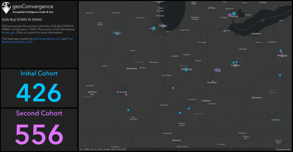
Media contact: Chris Wallschris@39dn.com(812) 320-5467 Indiana Geospatial Intelligence Firm Awarded 8(a) STARS III Contract The GSA 8(a) STARS III contract has a total value of $50 billion (Odon, IN – February 11, 2022) True North Joint Venture, LLC, an SBA 8(a) Certified Joint Venture with its managing partner being geoConvergence, has been awarded a coveted spot on the GSA 8(a) STARS III contract vehicle. 8(a) STARS III is a $50 billion, Best-in-Class contract vehicle that is designed to give 8(a) companies a chance to compete for governmentwide contracts. GSA reports 8(a) STARS III will give the government access to advanced technologies including artificial intelligence, robotic process automation, blockchain and other emerging technologies. True North Joint Venture, LLC is an All Small Mentor-Protégé joint venture formed between geoConvergence and Evanhoe & Associates. “This award gives our joint venture a tremendous opportunity to compete for and win work in a way we haven’t before,” said Prem Radhakrishnan, co-founder & CEO of geoConvergence. “We will be able to serve as a prime contractor and sole source opportunities while bringing on qualified subcontractors.” Evanhoe is equally excited and, according to Evanhoe Program Director, Kenny Wilson, “We’re looking forward to pursuing new work with geoConvergence on this very active governmentwide IT acquisition contract.” Currently, True North Joint Venture is one of 982 companies nationwide (seven of which are in Indiana) awarded a spot on the 8(a) STARS III contract vehicle. In receiving this award, geoConvergence was assisted by both the Indiana District Office of the Small Business Administration (SBA) and the Indiana Procurement Technical Assistance Center (PTAC), a division of the Indiana Economic Development Corporation (IEDC). “SBA and PTAC assisted us in navigating the complex federal contracts system and truly helped make this happen,” said Radhakrishnan. “This is a classic case of a state and federal entities helping private industry in its effort to scale,” said Mike Dodd, Dioltas Advisory Board Chairman, a strategic advisor to geoConvergence. “In this case, geoConvergence now has the opportunity to win multi-million-dollar contracts and have a true fiscal impact on the State of Indiana by hiring more employees and adding to the state’s tax base.” About geoConvergencegeoConvergence is a SBA 8(a) certified, minority-owned small business. The firm specializes in the design and implementation of world-class Geospatial Intelligence, Geographic Information Systems (GIS), and Space Management solutions by leveraging technical skills in Software Development (SecDevOps), Cloud Engineering, and Data Analytics required to create secure, effective, efficient, and resilient solutions in today’s highly connected network environment. For more information, visit https://geoConvergence.com