
geoConvergence at the 2025 Esri Federal GIS Conference

geoConvergence is proud to announce our participation in the Esri Federal GIS Conference 2025, the premier event for federal GIS professionals. As an Esri Gold Business Partner with Federal Small Business Ready designation, we bring two decades of experience implementing enterprise GIS solutions for federal agencies. Our leadership team – Prem Radhakrishnan (President & CEO) and Paul McBride (GIS Practice Director) – will be available to discuss how federal agencies can leverage spatial intelligence to enhance workplace efficiency and facility management. From our award-winning work with the Department of Veterans Affairs to our ongoing federal implementations, we have a deep understanding of unique challenges and requirements of federal GIS initiatives. Join us Wednesday morning at our booth as we showcase our collaboration with GeoCam, the first AI-Native Reality Capture Platform. Together, we’re developing innovative solutions designed to improve the efficiency of government buildings. Our joint focus centers on large portfolio-level facilities, demonstrating how building-level reality capture can automate the generation of ArcGIS Indoors data models and intelligent 3D imagery. During the demo, we’ll show how geoConvergence’s IndoorMa.ps offering processes GeoCam data and imagery alongside the ArcGIS Indoors data model to create a turnkey, scalable approach allowing Federal customers to build and operate efficient indoor mapping systems. Visit Us: Booth: F10 (Lower Level Concourse) Dates: February 24-26, 2025 Location: Walter E. Washington Convention Center, Washington, DC Join us to explore how our enterprise GIS expertise, indoor mapping solutions, and innovative partnerships can support your agency’s mission objectives. Whether you’re looking to optimize facility operations, enhance workplace efficiency, or implement enterprise GIS solutions, our team is ready to help transform your spatial data into actionable intelligence.
Digital Twin: A geoConvergence Story
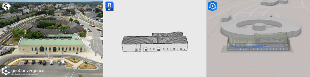
What is a Digital Twin? A digital twin is an accurate model of a real world building. The process for generating these models integrates data from various sources, such as building management systems, IoT sensors, and spatial information, to provide real-time insights into the indoor environment. This digital representation allows for enhanced visualization, analysis, and management of spaces, helping users optimize space utilization, streamline operations, and improve facility management through accurate, up-to-date information and simulations. Shaping the Future: The Impact of Digital Twins The integration of digital twins in ArcGIS Indoors is significantly shaping the future of the industry by transforming how indoor spaces are managed, analyzed, and optimized. Here’s how: Digital twins in ArcGIS Indoors provide a comprehensive, real-time virtual model of indoor environments. This allows organizations to manage and optimize space usage more effectively by visualizing and analyzing spatial data, which aids in everything from layout adjustments to strategic space planning. By integrating real-time data from various sources (like IoT sensors and building management systems) into a digital twin, facility managers can monitor building systems, track asset performance, and detect issues before they escalate. This proactive approach enhances operational efficiency and reduces downtime and maintenance costs. ArcGIS Indoors combines digital twins with advanced GIS capabilities, enabling detailed spatial analysis and data integration. This integration allows for sophisticated simulations and modeling, such as predicting how changes in one part of a building affect other areas, or assessing the impact of new developments. Digital twins improve user experience by providing interactive, user-friendly interfaces for navigating indoor spaces. For example, they can help with indoor navigation, optimize the placement of resources and services, and improve accessibility for building occupants. Our Digital Twin Solution geoConvergence has developed a refined process for data collection, model creation, and indoor feature services to provide an all inclusive facility management solution. No matter your starting point, we can provide a robust digital twin combined with the power of GIS tailored to your specific needs. Complete with your choice of wayfinding, space management, asset management, safety scenario planning, or a combination of these to improve operational efficiency. Our team of qualified team members works efficiently to create, improve and innovate these processes to deliver top of the line results. This speaks to the abilities of each member and their commitment to delivering the best results for our clients. With products like Autodesk Revit and Esri’s ArcGIS Indoors, we can bring to life what once was only a snapshot in time. Just a few years ago, it would seem impossible to be able to create a 1:1 digital model with all of these capabilities. Advancements in data conversion technology have improved the turnaround time for data collection and digital representation. We can now generate these models with more accuracy and efficiency than ever before. geoConvergence is committed to exploring these advances in technology to push the boundaries of what is possible.
Press Release – geoConvergence is now an Esri Gold Partner in the Esri Partner Network
geoConvergence is now an Esri Gold Partner in the Esri Partner Network