
Helping Baltimore County Public Schools (BCPS) Build a Sustainable Indoor GIS Program
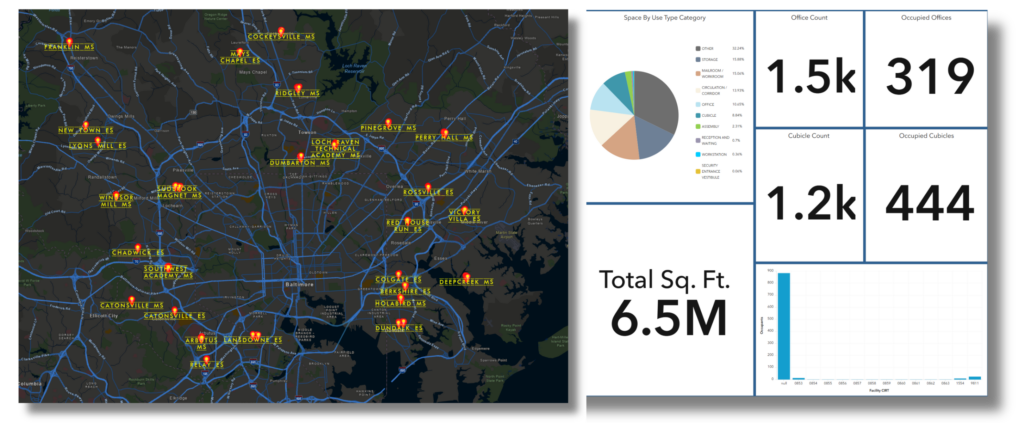
Helping Baltimore County Public Schools (BCPS) Build a Sustainable Indoor GIS Program The Skinny: Goal – Give BCPS an Indoor GIS system serving facilities, security, and emergency response. Partnership – Esri provided the ArcGIS Indoors product, geoConvergence provided CAD conversion, field validation, system integration, and implementation. The Challenge – 176 buildings with CAD files from different vendors/years needed a solution to handle scale and variability Operations-First Approach – Started with administrative facilities (maintenance depots, warehouses) to establish CAD-to-GIS workflows before scaling to school buildings. Field Validation – Physical walkthroughs across 70+ facilities using ArcGIS Field Maps verified CAD data against current conditions, capturing geometry corrections and safety asset updates in real time. Sustainable Program – Multi-year partnership; 2 years in, 5M sq ft digitized across 40+ buildings; ongoing maintenance as buildings and needs evolve. Baltimore County Public Schools (BCPS) needed Indoor GIS across 176 buildings. The challenge converting CAD files and building geodatabases wasn’t just technical. It was operational: creating a system that facilities managers, security personnel, and first responders could rely on. The project is structured as a five-year partnership, which shaped how we prioritize buildings, manage data, and think about long-term maintenance. Two years in, we’ve digitized 5 million square feet and deployed applications across 40+ buildings—including high schools, middle schools, and administrative facilities. Here’s how geoConvergence approached the project and what we’ve learned so far. The Challenge & Approach BCPS had CAD files for most buildings, but they were produced by different vendors across different years and standards. Our job was to standardize these drawings to import them into the ArcGIS Indoors Information Model so indoor data from all facilities could live in a single, consistent system. We processed each CAD file by separating content into standardized layers—rooms, walls, doors, floors, and assets. We then built a semi-automated workflow using ArcGIS Indoors for ArcGIS Pro and ArcPy to convert CAD layers into GIS feature layers with ArcGIS Indoors Information Model-compliant attribution. Because vendor CAD standards varied widely, we automated repeatable steps and performed targeted manual quality assurance/quality control (QA/QC) and made corrections where needed. Field Validation & Mobile Editing CAD-based conversions don’t capture everything. Legacy drawings often miss undocumented renovations, space reconfigurations, and asset changes. To address this, we conducted physical walkthroughs across 70+ facilities to validate the converted indoor data against current conditions. To support this field verification, we integrated ArcGIS Field Maps with ArcGIS Indoors to deploy floor-aware indoor maps in mobile devices. Field staff navigated each level and visually compared mapped features to real-world conditions, while also validating architectural elements (walls, doors, rooms, stairs) and safety assets (AEDs, fire extinguishers, and other emergency equipment). Geometry corrections, asset status verification, and attribute edits were captured in real time and synchronized back to hosted feature layers in ArcGIS Online—streamlining field operations, reducing post-processing, and ensuring verified updates were immediately reflected across the enterprise GIS system. Starting with Operations We didn’t start where you might expect. Before mapping a single school, we delivered 500,000 square feet of indoor data across BCPS operational facilities – maintenance depots, warehouses, and transportation hubs. That decision was deliberate. These facilities gave us a controlled, lower-impact environment to prove the end-to-end CAD-to-GIS workflow standardizing vendor drawings, applying ArcGIS Indoors Information Model attribution, and hardening QA/QC without disrupting student-facing spaces. At the same time, it delivered immediate value to facilities teams through operational workflows like asset management, space utilization, and occupancy planning. By the time we moved to schools, we weren’t piloting anymore—we were scaling a process BCPS had already used, validated, and trusted. Building for Multiple Stakeholders A district-wide Indoor GIS only works if the same authoritative indoor dataset can answer very different questions for very different stakeholders. We built the BCPS Indoors environment to do exactly that: Facilities teams use the system for space utilization and portfolio decisions (including lease avoidance), occupancy planning by linking HR headcount to buildings/spaces, and asset visibility to support day-to-day planning. Safety and operations use floor-aware indoor maps for evacuation planning and for locating and validating critical safety equipment (e.g., AEDs, fire extinguishers, emergency equipment). First responders need rapid access to floor plans by levels, exits, and key asset locations through their emergency management system. We published CAD-derived indoor GIS data to ArcGIS Online as web maps and services, then delivered the applications those teams needed: indoor map viewers, space planning tools, wayfinding/routing networks, and reporting dashboards. Lessons Learned The first years of deployment validated several key decisions: Beginning with administrative facilities established a strong foundation. Testing the workflow for facilities buildings before scaling to schools reduced risk while demonstrating value to facilities teams early. Field validation ensured data accuracy. CAD files rarely reflect current conditions. Physical walkthroughs identified undocumented renovations, relocated assets, and space reconfigurations. Field Maps enabled real-time validation and synchronization, maintaining efficiency at scale. Designing for multiple stakeholders upfront avoided retrofitting later. Facilities needed data integration for occupancy tracking. Emergency responders needed access through their public safety platform. Building these connections from the start meant one dataset serving multiple workflows from the outset. Structuring it as a long-term program supports sustainability. Buildings evolve, and operational needs shift. The multi-year framework accommodates phased deployment and ongoing maintenance, recognizing that Indoor GIS maintains true value when data remains current. For K-12 districts that might be evaluating Indoor GIS at scale, BCPS demonstrates how to build a system that delivers value, scales across an entire district, and remains sustainable over time. The Work Continues This isn’t a one-time deployment. geoConvergence maintains the system and the data, which includes adding new facilities, modifying existing ones, and removing obsolete facilities from the ArcGIS Indoors Information Model. Buildings change, and so do operational needs—the system evolves alongside them. We’re two years into a multi-year timeline, with three more years of phased deployment and continuous maintenance ahead. Phase 2 is ongoing, covering the remaining middle schools and dozens of elementary and special schools. This structure reflects a simple truth: Indoor GIS isn’t a project with an endpoint—it’s a core
IndoorMa.ps: A SaaS/PaaS platform designed exclusively for Indoor Mapping (Series Part 1)
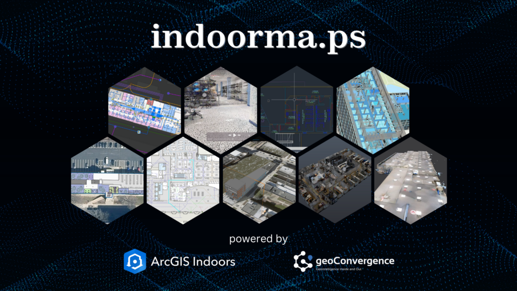
Indoor spaces hold significant potential for optimization, yet they also present unique challenges for organizations striving to enhance safety, efficiency, and utilization. In this first installment of our series on IndoorMa.ps, we introduce you to our groundbreaking SaaS/PaaS platform and its core capabilities. IndoorMa.ps, developed by geoConvergence, addresses these challenges with an accessible, scalable, and rapidly deployable SaaS/PaaS platform. As the first installment in our series, we’ll explore how through this dual approach, organizations can adopt a complete solution with licensing and hosting, or leverage their existing ArcGIS Indoors licenses with our hosting platform. Powered by Esri’s ArcGIS Indoors technology and backed by over two decades of GIS expertise, IndoorMa.ps allows organizations across industries to achieve unparalleled indoor spatial intelligence without the cost and complexity of traditional solutions. This flexible model ensures indoor mapping solutions are accessible to organizations regardless of their existing infrastructure. Whether starting with LiDAR scans or existing CAD/BIM data, organizations can quickly transform their spaces into interactive indoor digital environments hosted securely in the cloud. Offering powerful yet intuitive tools, IndoorMa.ps allows organizations to implement indoor mapping with minimal setup time or resource demands. IndoorMa.ps is also your one-stop shop for indoor mapping services, for data conversion, scanning services and more using our intuitive service request model. Our indoor specialists will provide quick assessments and quotes allowing you to purchase these requests and follow the service activity from your IndoorMa.ps dashboard. Key Features of IndoorMa.ps Rapid Deployment IndoorMa.ps can deploy indoor mapping environments in as little as one week when using existing spatial data, offering immediate use of wayfinding and space management tools. The platform processes standard BIM and CAD files through our data conversion services, maintaining spatial accuracy and building information hierarchies. For facilities without current documentation, our LiDAR scanning captures indoor spaces at sub-10 cm accuracy, generating precise digital basemaps. The data processing workflow supports multiple input formats and automatically configures navigation networks and space boundaries. Users can access their indoor mapping applications through a secure cloud environment, with all spatial data, floor plans, and routing systems ready for immediate use. Efficient Space Management IndoorMa.ps integrates with IoT sensors and Building Automation Systems (BAS) to deliver data-driven space management capabilities: The platform bridges physical and digital environments through an intuitive dashboard, giving facility managers the ability to reduce operational costs and improve workplace efficiency through data-backed space allocation decisions. Transforming Indoor Spaces with Data-Driven Solutions IndoorMa.ps represents a fundamental shift in how organizations approach indoor space management. Through innovative, pre-built CAD and BIM workflows and advanced data processing methodologies, we’re making enterprise-grade indoor mapping accessible and actionable for organizations of all sizes. What once required months of implementation and significant technical overhead can now be achieved swiftly, turning your static building documentation into a dynamic digital advantage that spans space optimization, emergency planning, asset tracking, and reservation management. The future of facility management isn’t just about maps—it’s about creating smarter, safer, and more efficient spaces that adapt to your needs. Our platform delivers exceptional value by combining solutions for space management, emergency response, facility scheduling, and asset tracking into one unified system. Whether you’re a government agency looking to improve public safety or a growing hospital system seeking to optimize patient care, IndoorMa.ps provides the foundation for your facility’s digital transformation. By combining rapid deployment options with proven cost savings, we’re making advanced indoor mapping technology accessible to organizations that previously found enterprise solutions out of reach—delivering a complete suite of facility management capabilities at a fraction of the traditional cost. About geoConvergence geoConvergence, an SBA 8(a) and HUBZone Certified firm, has been a trusted leader in GIS innovation for over two decades. As an Esri Gold Business Partner with Indoor GIS and Federal Small Business specialty designations, geoConvergence combines technical excellence with tailored client support. IndoorMa.ps is our firm’s commitment to transforming indoor mapping into a practical and accessible solution for organizations across industries. To explore how IndoorMa.ps can simplify your organization’s approach to indoor mapping, visit indoorma.ps. Follow us to be notified when the next installment is published.
Digital Twin: A geoConvergence Story
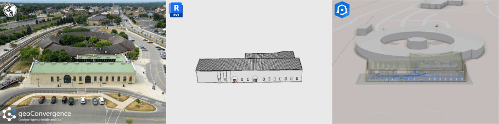
What is a Digital Twin? A digital twin is an accurate model of a real world building. The process for generating these models integrates data from various sources, such as building management systems, IoT sensors, and spatial information, to provide real-time insights into the indoor environment. This digital representation allows for enhanced visualization, analysis, and management of spaces, helping users optimize space utilization, streamline operations, and improve facility management through accurate, up-to-date information and simulations. Shaping the Future: The Impact of Digital Twins The integration of digital twins in ArcGIS Indoors is significantly shaping the future of the industry by transforming how indoor spaces are managed, analyzed, and optimized. Here’s how: Digital twins in ArcGIS Indoors provide a comprehensive, real-time virtual model of indoor environments. This allows organizations to manage and optimize space usage more effectively by visualizing and analyzing spatial data, which aids in everything from layout adjustments to strategic space planning. By integrating real-time data from various sources (like IoT sensors and building management systems) into a digital twin, facility managers can monitor building systems, track asset performance, and detect issues before they escalate. This proactive approach enhances operational efficiency and reduces downtime and maintenance costs. ArcGIS Indoors combines digital twins with advanced GIS capabilities, enabling detailed spatial analysis and data integration. This integration allows for sophisticated simulations and modeling, such as predicting how changes in one part of a building affect other areas, or assessing the impact of new developments. Digital twins improve user experience by providing interactive, user-friendly interfaces for navigating indoor spaces. For example, they can help with indoor navigation, optimize the placement of resources and services, and improve accessibility for building occupants. Our Digital Twin Solution geoConvergence has developed a refined process for data collection, model creation, and indoor feature services to provide an all inclusive facility management solution. No matter your starting point, we can provide a robust digital twin combined with the power of GIS tailored to your specific needs. Complete with your choice of wayfinding, space management, asset management, safety scenario planning, or a combination of these to improve operational efficiency. Our team of qualified team members works efficiently to create, improve and innovate these processes to deliver top of the line results. This speaks to the abilities of each member and their commitment to delivering the best results for our clients. With products like Autodesk Revit and Esri’s ArcGIS Indoors, we can bring to life what once was only a snapshot in time. Just a few years ago, it would seem impossible to be able to create a 1:1 digital model with all of these capabilities. Advancements in data conversion technology have improved the turnaround time for data collection and digital representation. We can now generate these models with more accuracy and efficiency than ever before. geoConvergence is committed to exploring these advances in technology to push the boundaries of what is possible.
Mapping Facilities and Assets inside the Hospital
Mapping Facilities and Assets inside the Hospital A custom GIS application at the University of Kentucky (UK) now supports occupancy of the 16-floor, 1.2-million-square-foot Level 1 Trauma Center, called UK Chandler Hospital Pavilion A. Maps and room data sheets detail each room along with occupancy and accompanying assets including furniture, medical equipment, and technologies. Built on an ArcGIS platform, the application was developed by Michelle Ellington, UK GIS coordinator, and Andrew Blues, UK information technology manager, along with 39°N, an Esri business partner. “We have a lot of information silos, but this application will serve to analyze all that data in one centralized location,” Ellington said. “We chose GIS because it is a scalable solution for integrating data types and university-wide systems.” Custom enhancements include the integration of CAD drawings, room data sheet generation, 360-degree panoramic pictures of rooms both fitted and in the predrywall stage, on-the-fly symbolization, Web site linking, and a powerful asset editing module. The system is being expanded to integrate other campuswide systems and support additional university needs. “We built the custom ArcGIS Server application using the Flex API to maximize accessibility and ease of use,” said Chris Walls, cofounder of 39°N. “We are extremely proud of this cutting-edge collaboration with the University of Kentucky. This kind of application will significantly streamline the administration of public facilities.” For more information, visit 39degreesnorth.com and esri.com/health or contact Michelle Ellington at michelle.ellington@uky.edu. Link to original article: ArcNews healthyGIS Winter 2010/2011